So .. back to writing after a long break (first travel, and then illness). Continuing from where I left off at Chandratal.
After a peaceful (or not) sleep at Chandratal (we stayed at a lovely campsite called Parasol camps), I thought morning would be a bit less freezing. Woke up at around 4:00 am only to find it’s still cold, and I’m still freezing. Couldn’t go back to sleep and couldn’t (or wouldn’t dare to) step outside the tent, I just lay there waiting for daylight and others to be up.
We had to move back to Manali today, and of course there was the Pagal Nala on the way. So to avoid the mad rush (wouldn’t have complained if we’d go stuck again though) at the nala we packed up and started our journey immediately after breakfast. It’s a long drive from Chandratal to Manali via Rohtang pass. We did manage to avoid the rush and madness at Pagal Nala but the “getting stuck in traffic on Himalayan roads” was written in our horror-scope for the day.
So on the way to Manali, we had to cross Rohtang. And what a surprise when we reached Rohtang. The Rohtang pass we experienced on the way to Kaza and what we saw on the way back to Manali – huge difference. It was crazy crowded. But the climate was just awesome. We did get down to enjoy the weather. Had bhutta and tea (of course!).
the “parking lot” at Rohtang.
After a short break at Rohtang we continued our journey to Manali. Encountered fog, clouds and some light drizzle along the way. Lovely road trip weather! There was an accident on the way (truck tyre just off the road probably) so traffic was held up and the cops were allowing only a single line of vehicles.
As we approached Manali, we saw plenty of vehicles all stopped in a single file. Wondered what it was – accident, or road work or something else. Didn’t find out the reason for it but utilised the short break to step out of the vehicle and click pics. Weather was pleasant, and even though the cars were all stuck no one was honking or abusing each other 🙂 Only thing missing here was a chai tapri.
.. and all that I can see is another Apple tree (with due apologies to Fool’s Garden)
We reached Old Manali late afternoon, and were greeted by rain and an awesome climate. Oh, reaching Manali also meant we were back in network coverage area!! Lot of catching up to do – checking mails, texts, posting pics on insta and all. Busy times ahead! 😉
Since there wasn’t anything planned for the evening – I spent the rest of the evening packing and re-packing and re-packing again and .. re-pa… (okay enough 😉 ) my backpack. Freshen up and a little nap(not before having a cup of tea) and woke up to see it was pitch dark outside. It was still raining, and was pleasant (not freezing cold like at Chandratal).
What a picture!! Shamelessly praising my own click .. but hey. It’s CHAI and MOUNTAINS.
After dinner there was yet another round of re packing my backpack — wanted to make sure it’s as compact as possible (lol), I drifted off to sleep. We reached Manali on a Friday afternoon, and the next day (Saturday) we were to start our journey for Delhi (by HPTDC bus). Reach Delhi early Sunday morning, and then catch flight back to Mumbai.
So that was the plan – all set and looking forward to reaching home on Sunday.
(to be continued….) Stay tuned. More adventures coming up!!
Today we’re off to Chandratal. Woke up around 5:15 and opened the window to the sight of the golden peaks. The early morning sunrays reflected on the snow capped peaks had given it a golden hue. Such a lovely sight.
I had been waiting to visit Chandratal since the start of the trip. This was supposed to be the highlight of the trip for me. Started from Langza fairly early, as we had to visit a couple of places along the way.
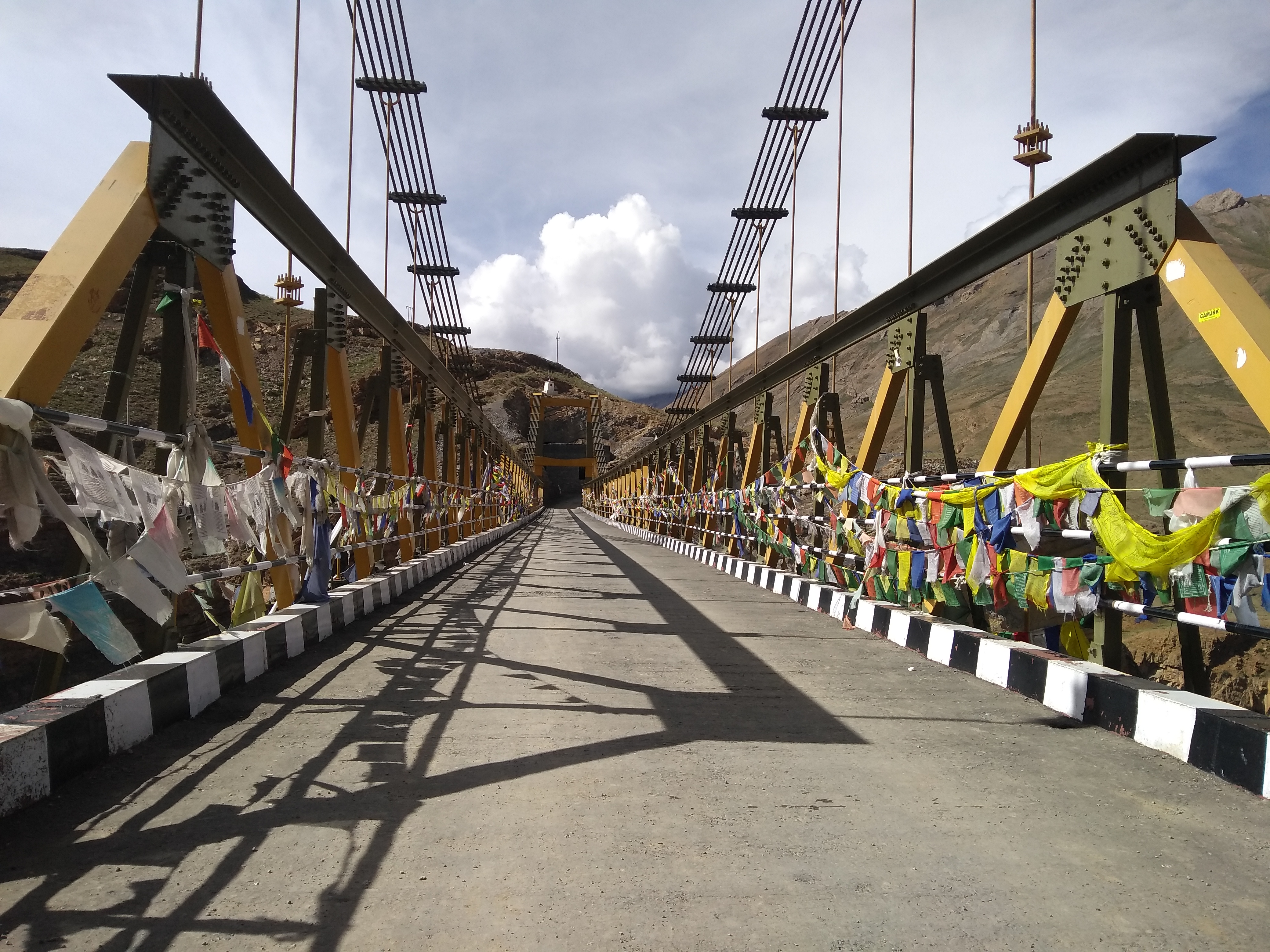
First up was Chicham Bridge. This bridge was completed and opened to public in 2017 and took around 13 years to complete. One for the record books – this bridge gets tag of being the highest bridge in the world. (alt 4145 m above sea level). It was opened to the public on Aug 15, 2017. So we visited on it’s second birthday 😀
The bridge connects the villages of Kibber and Chicham and has reduced the travel time between these two villages considerably. The bridge is built over a 1000 ft deep gorge, and it gives you a rush looking down from the bridge. Don’t try this if you’re scared of heights. Earlier there was a self operated ropeway over the gorge and you had to pull the ropes to travel from one end to another. Imagine if something went wrong, and you’re stuck in the middle of that 1000 ft gorge and no one to help. Just imagine. Scary, isn’t it?
Chicham is a great place for photographs .. i.e. if you’re the selfie/group photos kind of person. The bridge, and the surroundings are also great, but you can’t find the bridge empty for long. There’s always someone who’s riding along or taking pics. Lot of biker groups on the day we visited.
Photos done, and we started for Chandratal. We had to cross Kunzum pass to reach the lake. On the way from Kaza to Manali just after Kunzum there is a detour that takes you to Chandratal. It is not a proper road (heaven for offroading though).
We did stop at Kunzum, just like we had done on the way to Kaza. Everyone stops there.
Welcome to Kunzum Pass
By now I was getting really impatient to reach Chandratal 😀 and it showed. I don’t have many pics at Kunzum (not as much as I clicked on the way to Kaza, lol!). So moving towards Chandratal, we did stop for lunch along the way and reached the Chandratal campsite mid afternoon.
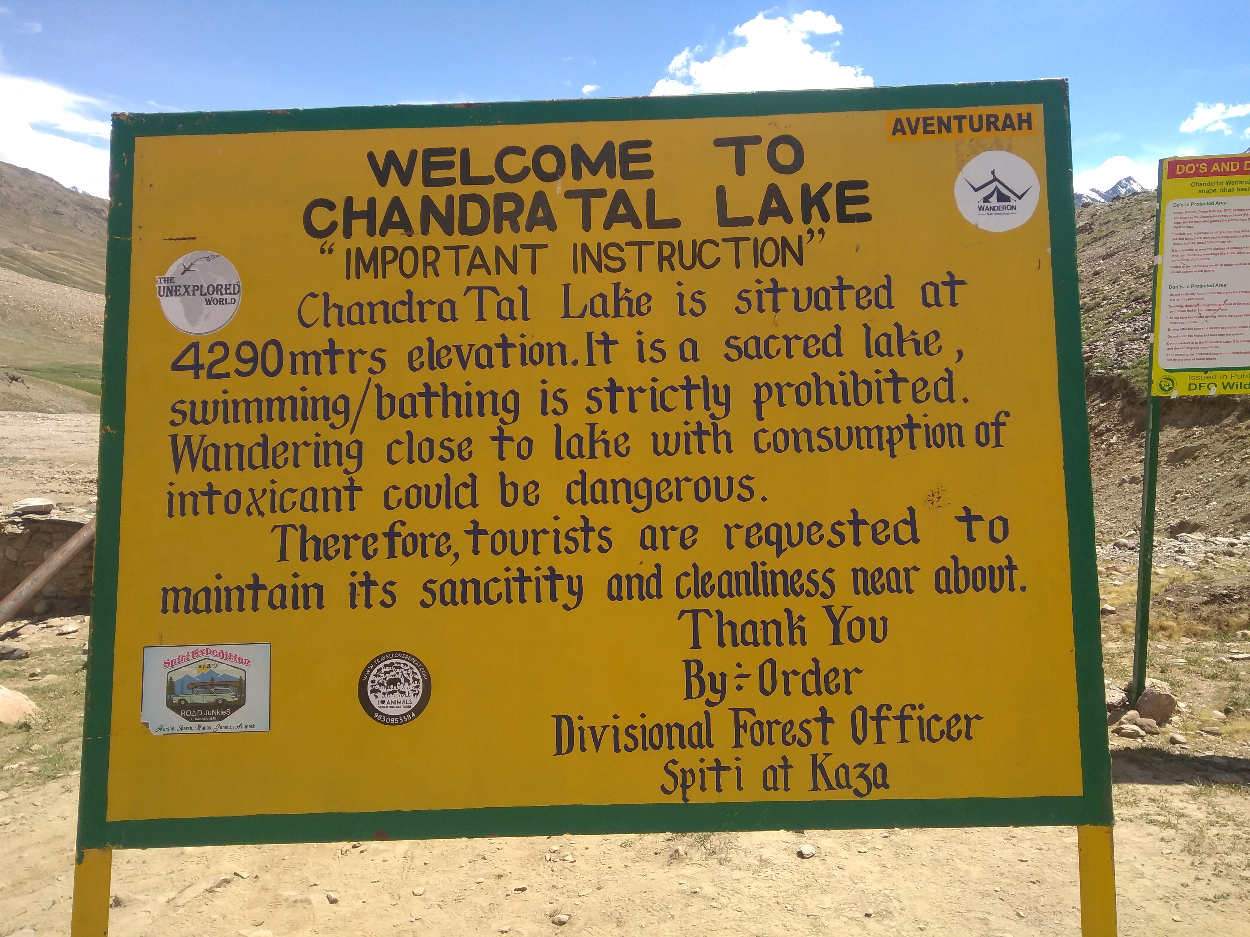
Chandratal is a high altitude lake situated at 4290 m above sea level. It is considered sacred by the locals and hence swimming/bathing or even entering in the lake is forbidden. But there are some assholes who do that (it’s a free country, no?). So don’t be an asshole. Respect local traditions wherever you travel.
Enough of asses.. Now about the lake. Chandratal means Moon Lake (Chandra = moon, tal = lake). The lake is so called because of it’s crescent shape. It is one of the two high altitude wetlands in India and is designated as a Ramsar site (the other is Tso Moriri, Ladakh). For more information about Ramsar site, and what it means, visit here.
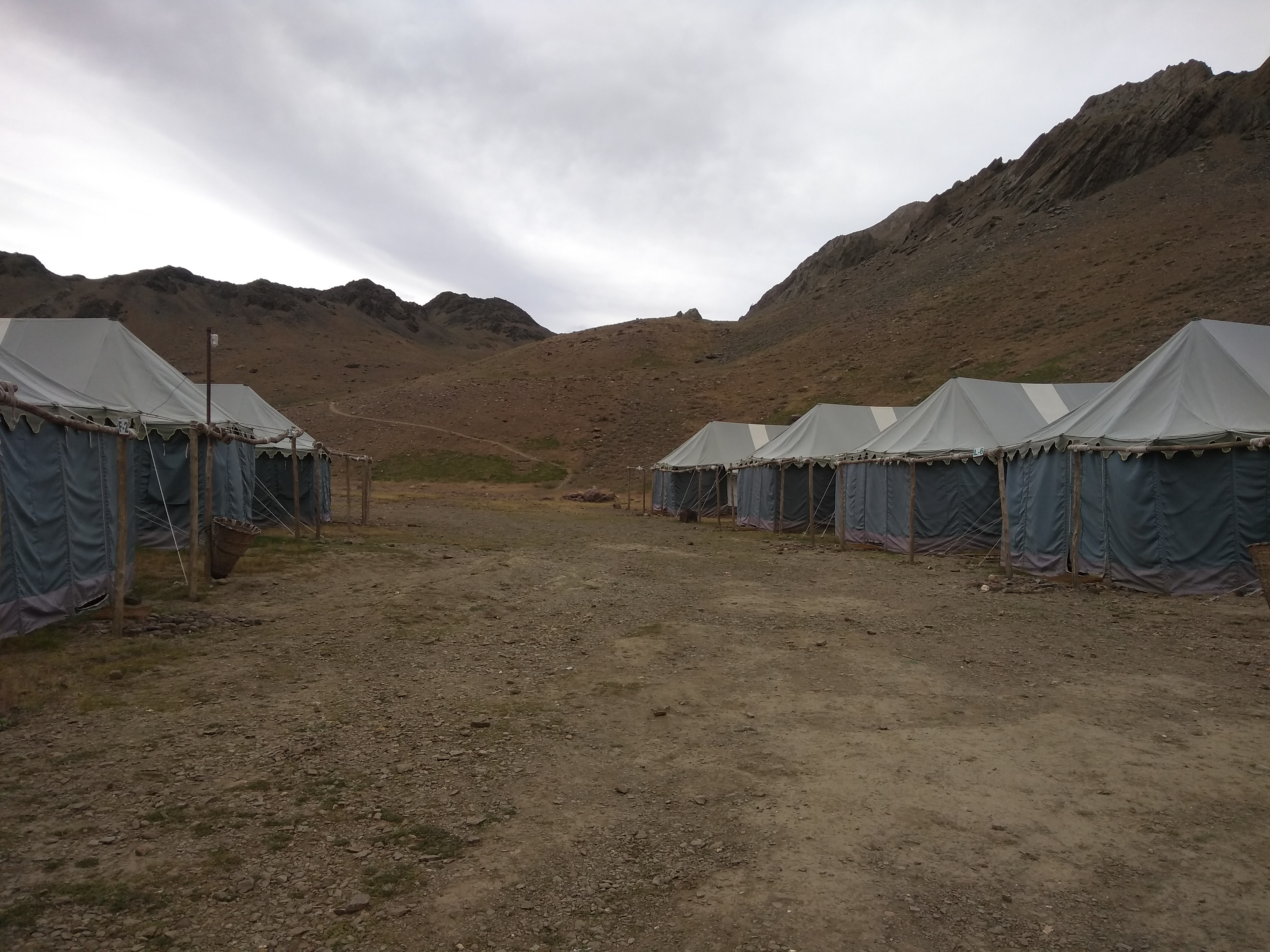
There are no permanent structures at Chandratal (so no hostels, homestays etc), but if you have to spend the night, then campsites/tents are available. Lake side camping is banned since it is a very sensitive ecological zone. Campsites are located at a distance (around 2-3 km) from the lake. Vehicles also are not allowed to go up to the lake. There is a designated parking space for vehicles, and everyone has to walk up to the lake. Being at a high altitude, the short (around 20 min) walk is a bit tiring, and some people also get breathless. But the beautiful lake at the end of the walk makes up for it. Totally worth the trek .. all huffing and puffing to witness the glorious lake.
The waters of Chandratal are so crystal clear that they reflect the colours of the mountains, clouds, sky. So depending on whether the sky is clear, or has grey clouds the waters are deep blue, gray, or a mixture of brown/green/blue.
At Chandratal. Finally! This is where I go beserk .. clicking away. I had my DSLR and mobile with me. Clicked so many pictures here, I have lost count.
This lake is so beautiful during day time, can’t help imagine it’s beauty at night. Pitch darkness, the clear skies with millions of stars twinkling and their reflection in the still waters. And if there’s a moon (full moon, ideally), it would be even more awesome.
Though I didn’t see any boards or warnings about staying lakeside during the night, it could be a bit risky as it’s a fresh water lake and animals could visit it. And then there are always the stories about magical creatures living in the lake.
It’s difficult to NOT go crazy here
Chandratal is HEAVEN! Spent a lot of time at the lake. And then finally it was time to return to the campsite. The waters that were a deep shade of blue when we reached the lake were slowly turning grayish, as the weather changed and dark clouds started appearing in the sky.
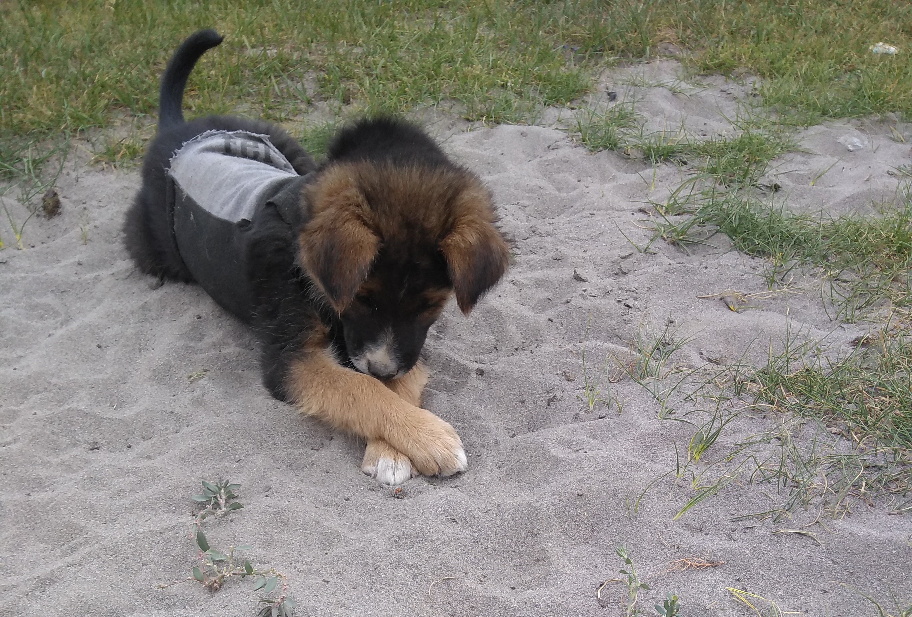
We reached the campsite in time for snacks (pakoda) and tea. There are no shops at Chandratal, so you need to carry food/snacks with you. Since there are no permanent structures at Chandratal, we stayed in tents. The location of the campsite was too good.. tents, surrounded by mountains on all sides. Oh, and there were dogs as well. Win-win!!
So after the pakodas and a refreshing cup of chai, there was a round of chitchat and clicking of crap photos (by me, obviously) inside the tent. Soon it started getting dark, and cold. By cold I mean R-E-A-L-L-Y cold. I had worn a base layer, 2 tshirts, and a down jacket. Gloves and a beanie as well. LOL! Still cold. By dinner time, I was freezing. Don’t laugh.
Dinner was inside another tent, and we had to really search for chairs. Almost everyone at the campsite had come for dinner at the same time.
Post dinner went for a short walk at the campsite. It was a full moon night, and the moon was just about rising from behind the mountains. This was a beautiful sight. I stood there, freezing, watching the moon. What a sight!! Just awesome. No pictures. Wouldn’t be lying if I said “I stood there frozen, watching the moon” .. as I was literally freezing out there. I didn’t have my DSLR out with me, and didn’t attempt to click with my phone camera. Couldn’t click rather, with gloves and all. Didn’t dare take off the gloves.
Some from the group did click pictures of the moon, and they were wonderful.
Some cameras captured 3 moons instead of 1 (ज्याना समजलं, त्याना समजलं) 😉
So with all the memories of Chandratal and the wonderful sight of the full moon, I went off to sleep. It was still freezing, and I was wondering and worried about what to do the following morning.
Day 5 of Spiti vacation begins with a rainbow!! It drizzled the previous night, and there was a light drizzle in the morning as well. Woke up earlier than usual (this is slowly becoming a habit – early to bed, early to rise), opened the window to see a faint rainbow. It disappeared even before I could get my camera. So no pictures. But you can imagine .. the snow capped mountains, clear blue skies with some patches of grey clouds, and a rainbow.
There was still some time for breakfast, so went for a short walk in the village. Walked past the Tabo monastery, and right up to the helipad. There is a small helipad in this village! Had a heavy breakfast before leaving for Langza. Today is going to be a day of visiting some of the highest places in the world.
Good Morning from Tabo
Langza is more famous for it’s Buddha Statue. The statue is 35 feet high and situated on top of a hill. But few people know there are also fossils found in this village. More on that later.. first let’s travel to the top of the world. Come along!
We set off from Tabo immediately after breakfast – not immediately, there was a round of group photo session 😉 Oh, and there was aaloo paratha for breakfast. Thankfully it wasn’t monster sized like the one at Kaza.
Our first stop (officially) for the day is Hikkim. Also famous as the Highest functioning post office in the world. I say officially because we took (and everyone should) multiple stops along the way. There’s so much beauty all around that you should stop and admire and take pics. The entire journey is so picturesque.
Views like these … and these …You fill it up with memories… maybe that’s why we call it “Memory Card”
So after multiple pit stops along the way, we finally reached Hikkim. Hikkim Village at an altitude of 4440 m (14567 ft) above sea level, is very famous because of the Highest Post office in the world. Hikkim was also mentioned in Limca Book of records as being the highest polling station in the world! The honour is now with a village called Tashigang, also in Spiti. So literally we were on top of the world! This post office was established in 1983 and has a pin code 172114. The post office is a tiny one room office and is built as per the local way (using mainly stones and mud, with a layer of dry grass on the roof) and it also has prayer flags. The post office also doubles as the post master’s home. That is why you are supposed to take off your footwear before entering.
Would you like to send a letter from here?
The post office was very crowded when we were there. There were lot of people surrounding the post master, all asking questions regarding when their mail would be delivered and so on. I decided to send two post cards from here.. one picture postcard and another (yellow coloured) India Post postcard that is available at any post office in the country (sometimes at paan walas also). I needed to paste a Rs6 stamp on the picture postcard. The yellow India Post card already had a stamp on it. And as it turns out .. they were out of stamps. The post master (such a patient, kind man) was explaining to everyone that since they do not have stamps at the moment, he will personally paste stamps and post the cards when the stock arrives. He must have said this at least to 50-60 people while we were there! And not once did he raise his voice, or say it in an irritated manner. Actually I have noticed this quality in people living in the hills (also at Sikkim). They have such tremendous amount of patience. Maybe it’s the tough life up in the mountains that gives them this superhuman quality. Truly inspiring. I would have punched someone if I had to repeat the same thing over and over again.
Oh, by the way I did leave Rs 6 for the stamps with the master. And as promised, the stamps were pasted and the cards were posted. I was at Hikkim on Aug 14, and received the postcards (both!!) by 28 Aug. Both cards were addressed to my nephew (4 y 8 m). I hope someday when he’s old enough he will know the thrill of getting letters. This whatsapp and instant messaging generation doesn’t know the joy of waiting for the postman (sometimes dread as well – our school results were sent by post 😉 )
Hikkim post office .. peeking from behind the hill
One thing about the how the system works here, and maybe that’s the reason why it takes so long for you to receive your mail : the mail is carried on foot till Kaza, from where it is sent by bus to Rekong Peo, and from there to their respective destinations. The post office remains shut during winter months as snowfall makes it inaccessible.
Mortar + pestle – at Hikkim village
So after posting the cards (and me thinking that the art of writing letters has disappeared) we moved to Komic. Not before having a cup of refreshing ginger+honey+lemon tea and buying some souvenirs (fridge magnets!!).
Komic (alt 4587 m above sea level) is popular as being the highest village in the world connected with a motorable road. This village has a population of only 114, and is also the home to the “Highest restaurant in the world”. No, we didn’t eat here.
getting “high”
This village also has a monastery (Tangyud monastery). This monastery is said to be over 800 years old and was probably shifted from the neighbouring village of Hikkim during the 70s due to damage by earthquake. The monastery has a stuffed effigy of a snow leopard! There is also a prayer hall where women are not allowed inside.
Tangyud Monastery
Spent a lot of time at Komic – there was a cool breeze blowing. Since this village is located high on top of a mountain (like the other villages in Spiti valley), it provides you with a superb vantage point. All around you are mesmerizing views of the Spiti valley. Aargh .. I’m using big words like mesmerizing, breathtaking, and so on .. must be the mountain air 😉
So, after spending a lot of time at Komic, we moved towards our final destination for the day, Langza.
Langza village (alt 14300 ft above sea level), is famous for it’s Buddha statue. This statue is said to be ~1000 years old, and is situated on top of a hill. From the village it is a short (or not) 25-30 min uphill climb to reach the statue. Or you can also drive. The Buddha sits on top of the hill, watching over the village of Langza. Due to it’s location (on a hill), this statue is visible as one approaches the village. Langza is a very small village, and the home stays at this village are very basic. Don’t expect anything fancy in these places. Also like the rest of the Spiti valley mobile connection (with exception of BSNL) is absent. It’s a very different experience (and awesome too!) to be disconnected from the rest of the world.
35 feet – Buddha Statue at LangzaLangza village, and the Buddha statue (seen as a tiny speck) – zoom to view.
Langza is also called the “fossil village” due to the presence of fossils in and around the village. These fossils are of ancient marine animals and plants and are over a million years old. How did a marine animal/plant reach the Himalayas? Well, this is more than a million years old. The Himalayas as we know today wasn’t a mountain range, and this region was submerged in the Tethys sea. ** For more lessons on Himalayan geography, please google 😉
The fossils are called “Chaudua” in local language and you can see village kids searching for them near the statue.
Langza Buddha
We reached our homestay at Langza late afternoon, and after a quick lunch (simple meals – daal, chawal, vegetables) we set off to the statue.
This may sound repetitive, but here goes.. once on top of the hill the 360° views of the picture postcard village. Best for photography, or just sitting watching the views. It was cool (lovely breeze) up there, also sunny, also windy, and popcorn clouds. Words, and photographs don’t do justice to the beauty of this place (all of Spiti actually!).. still here are some photos clicked at Langza.
Views from Langza
Back to the homestay after spending a lot of time at the Buddha statue – needed some rest before dinner.
Oh, btw .. the view from my room here was simple amazing. The window was right opposite the Buddha statue. The best view in the house. Yay!
view from the window (it’s 5X zoom – the statue isn’t that close)What a lovely view to wake up to .. golden peaks! (clicked at 5:25 am, Aug 15, 2019)the room with the best view! (Lara’s homestay, Langza)
After a simple dinner (daal chawal) it was time for lights off.. wasn’t tired as such, but had a mild headache, so wanted to rest before the journey the next day.
We were at Langza on August 14, 2019. The next day (Independence day!) we will be travelling to Chandratal. The place I was so eagerly waiting to visit since the start of Spiti trip. It’s almost the end of the trip, and as they say “save the best for the last”.
With views like this at almost every step of the journey.. Spiti is indeed a heavenly place. Words, and photos don’t do justice.
So.. day 4 of vacation. I’m finally in Spiti valley. We reached Kaza late last evening after a long drive from Manali. Visited some awesome locations along the way.
Today we move from Kaza to Tabo. After a hearty dinner and early lights off, I woke up refreshed and ready to hit the road. Today’s journey will take us to some of the oldest monasteries in the region (and the most beautiful too!). But first … Breakfast. I had ordered a aaloo paratha, and it arrived last. Though I had a bit of poha before the paratha arrived. But when I saw what was in the plate (aaloo paratha, of course).. I was speechless. It was a jumbo paratha. It was yummy though. I didn’t click any pics, as I was too busy and preoccupied trying to figure out how to finish it. Note to self: If I visit this place again (I know I will), I’ll probably have to skip dinner and then order this monster size paratha for breakfast. 😉
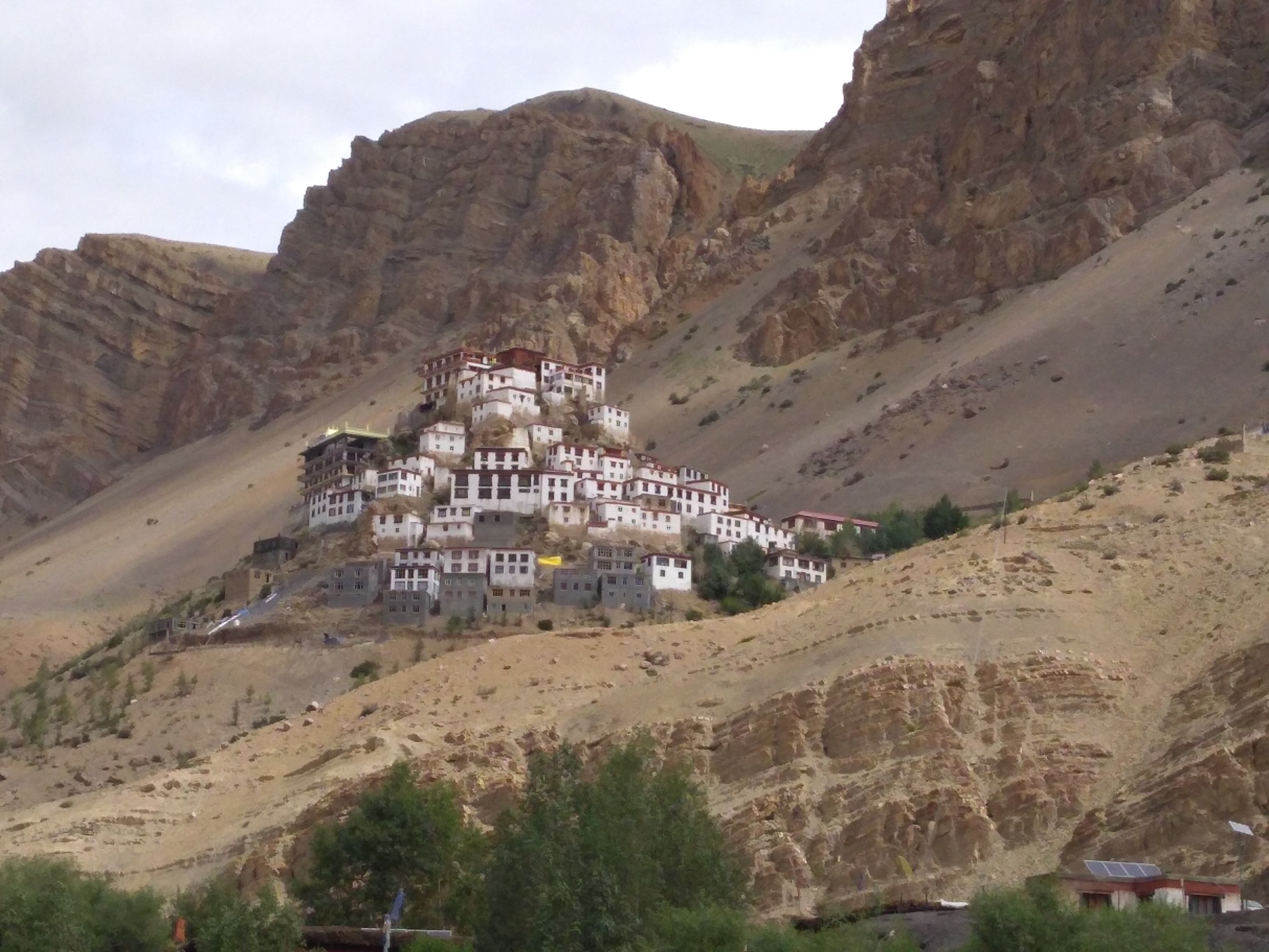
Key Monastery (alt 4,166 metres (13,668 ft))
After breakfast and a customary group pic, we set off for Ki Monastery (this is sometimes spelt as Kee, or Key). Ki monastery looks like a bunch of houses stacked on top of each other haphazardly. There is an interesting story about why the monastery looks like this. Multiple attacks, wars, earthquake, and even fire have all had a part in the monastery being constructed like this. Each time the monastery was damaged due to the above mentioned reasons, it was rebuilt. And so the building looks like it’s buildings arranged as multiple blocks.
Key Monastery is situated at an altitude of 4,166 metres (13,668 ft) ASL. It is one of the biggest monasteries in this region, and is also a training school for monks. There are +300 monks living/studying here. There are 3 floors and the rooms on the upper floor (called Tangyur) has beautiful murals. You can also climb up to the roof of the monastery, and be treated to some breathtaking views of the valley.
After spending some time at Key, we moved towards the next monastery, Dhankhar Monastery. Today is a day of visiting monasteries!
Dhankhar literally means fort on a cliff – Dhang = cliff, Khar (kar) = fort. The monastery was also a fort meant for protecting the village during ancient times. It is built on a cliff, and offers a splendid view of the Spiti valley and the river. The approach road to the monastery is very narrow, and is a dirt track. So if you need to park your vehicles at some distance and walk up the road. If using public transport you can take the daily HRTC bus from Kaza to Recong Peo. But you have to drop off at a village called Schichilling, and then either trek up to the monastery, hitch a ride with some locals (usually tractors going to the village), or hire a taxi.
Dhankhar monastery is built of stones, mud and wood, and hence is also very vulnerable to weather erosion.
It is very dark inside the monastery, and the passages/stairs are very narrow. There was a board at the entrance which says only 20 people are allowed inside the monastery at any time. Also saw a board about a group (called Dhankhar Initiative) working on conservation and restoration of the monastery.
It was mid afternoon so we had lunch at Dhankhar before leaving for Tabo. Post lunch there was a small photo session with the doggos outside the monastery.
So, after the photo session with the puppers, and doggos we set off for Tabo. Our final destination for the day and also the location of Tabo Monastery. Of course there were photo pit stops!!
The long winding roads, and the mountains for company. This is pure bliss!
Tabo village is situated on the banks of the Spiti river and is home to the Tabo monastery (Established in 996). The monastery is over 1000 years old and is also called as “Ajanta of the Himalayas“. The Ajanta reference is due to the presence of a large number of murals and paintings here. There is also a lot of thangkas(painted scrolls). The monastery is a simple structure built from mud. One important point, the monastery and prayer hall closes their doors at 5:30 pm, but the monastery complex is open. So plan accordingly. The monastery and prayer hall is open from 5:00 am to 5:30 pm every day. We reached Tabo around closing time so didn’t get much time to visit the monastery. It was pitch dark inside the prayer hall when we got there, and it was time for evening prayers. It was a surreal experience, sitting in the dark and hearing the prayers and the drums.
Though we didn’t get enough time inside the monastery we did spend a lot of time in the monastery premises. It is surrounded by huge intimidating mountains from all sides. In addition to this monastery, there is also a new monastery adjacent to the original one.
Tabo Monastery
near the new monastery
Welcome to Tabo
There was a light drizzle in the evening, and the weather was just wonderful. It was also two days before the full moon day. Went for a walk after dinner. Lovely short walk, cool breeze, darkness and the almost full moon!
Evenings like these …
the (almost) full moon at Tabo
Few pointers: Plan your journey so that you reach Tabo much before the closing time (5:30 pm) if you are not staying for more than a day. If you do not have enough time in the afternoon/evening, then spend time in the monastery premises in the evening and visit the monastery the next day. They open the door at 5:00 am. Photography is not allowed inside the monastery.
Go for a walk in the evening, or early morning. I walked up to the helipad (yeah, there’s one in this village) the next morning. These walks, and the fresh air definitely help in keeping you alert and refreshed the entire day.
Day 1 and 2 of Spiti vacation were spent in travelling, and rest/acclimatization. Today – day 3, is when the real adventure starts. We’re off to Spiti!
A bit about the travel for the day – it’s a very long journey (about 10-12 hours). So it’s going to be an early start.
Set the alarm for 4:30 am and went to bed early last night.
Up even before the alarm sounded — yeah, I was that excited 😀 A few minutes to freshen up, and I was all set. Ready to start … for SPITI!! The josh was so damn high. It was raining that morning (just a light drizzle, actually). But the rains, and the mist had created a lovely effect. The clouds, and the mist and the rains on the mountains.. Wow, what a view. The kind of views you want to wake up to everyday!
waking up to this view …
We started from Manali around 6:00 am. Today’s journey will take us to some of the highest mountain passes in the world (Kunzum. Rohtang). Since it was raining that morning, everything looked so fresh and green. I was conflicted – whether to click pictures or just sit back and admire the scenery. Did both 😉
After a couple of hours of driving through some of the most scenic roads, we arrived at our first pit stop for the day – Marhi. This is a small village (maybe?). It is on the way to Rohtang, so I guess it is some kind of a break/rest place as there are lot of dhabas at here.
A quick break for tea (of course!) and we were off to our next pit stop, ROHTANG. Rohtang Pass (Rohtang La). Located at an altitude of 13,058 ft, this pass connects the Kullu and Spiti valleys. It is ~ 60km from Manali, and one has to cross this mountain pass while travelling to Leh or Spiti. This pass is closed during winter months.
“Rohtang” means a pile of corpses. This pass got its name due to the huge number of people dying while travelling along this route during ancient times.
Rohtang being a very popular tourist destination is very crowded during weekends. Though there are checks in place now to restrict the number of vehicles that visit Rohtang per day. Since it was a weekday (Monday that too!) when we visited on the way to Spiti, we were lucky enough to avoid the crowds.
We stopped at Rohtang (who doesn’t) for photographs, and also just to soak in the views.
While clicking pics at Rohtang I realised my mobile has lost signal. I think we lost signal at some point after Marhi. There is no mobile network in Spiti except BSNL. Keep this point in mind when travelling to Spiti. You are disconnected from the world during your time there. Not that I mind – it was great to be offline for a week.
So after Rohtang, the next stop was for lunch. And we set off from Rohtang with this in mind.. BUT… there was an adventure in store for us. Something we were not expecting. The famous ‘Pagal Nala’. The road to Spiti is full of such small/big nalas, and Pagal Nala being the most famous. Nala is a stream crossing the road, and such sights are very common along the Manali-Spiti/Leh road. You get to see such nalas because as the sun rises, the snow melts on the higher reaches of the mountains and creates such streams.
Pagal Nala. Sometime later (maybe an hour?) we saw a long line of vehicles. Cars, buses, even bikes. This is the famous nala. Basically the water, rocks, and uneven surface makes it very difficult for vehicles to cross this patch. Stepped out of the vehicle, just to stretch my legs and click some pics. Watching people help other cars to cross the nala. It was an experience. I think Pagal Nala cannot be described in words. It has to be experienced.
Pagal Nala
After a long delay we crossed the nala with some difficulty, and finally arrived at Batal for a late lunch. Lunch was at a small cozy dhaba (Rang yul) – the usual mountain food – maggi, daal chawal.
After lunch we set off again to our next stop, Kunzum Pass.
Kunzum Pass (Kunzum La), located at an altitude of 4590 m (15,060 ft) is an important stop on the way to Spiti (from Manali).
The Kunzum Mata temple here holds a lot of importance to the travellers and they stop here to take her blessings. It is said that Kunzum Mata watches over the mountains and protects the travellers on this dangerous roads. As per the local tradition no one drives past the temple, they have to go around the temple (pradikshina) and seek blessings. The temple is surrounded with prayer flags, and it is such a beautiful sight watching these flags fluttering in the breeze. You can see the Spiti valley on one side, and the Chandrabhaga ranges on the other side from here.
After driving through some of the most dangerous (but beautiful) terrain, we finally reached Losar. This is the first village in Spiti when travelling from Manali. So we officially entered Spiti Valley sometime late afternoon. There is a check post here, and so had to stop for the formalities.
Finally here!
Once the formalities were done, we started again on our way to Kaza which was the final stop for the day. The road to Losar is very monotonous. By this I mean, there’s absolutely nothing for miles. No trees, no settlements, no villages, no dhabas along the road. Absolutely nothing! The saying “The toughest roads lead to the most beautiful destinations” seems so apt here. Yes, the roads are tough, and some places there are no “roads”. But the landscape, the views you encounter along the way are simply breathtaking. Can’t complain about the roads and dullness when there’s so much beauty all around you. After driving for about 30-40 minutes after the check post (some villages along the way) we arrived at a small dhaba like place – for TEA! I was desperate for a cup of tea, and was so damn happy when we stopped 😀
After a refreshing break (black tea, with lemongrass – heaven!) we were back on the road and to the final destination, Kaza. There was a light drizzle when we started our journey and the temperature had come down quite a bit. For me at least. Used to living in the furnace that is Mumbai, even a slight drop in temperature and it feels like I’m at the north pole.
Finally, after a long, tiring day we finally reached Kaza late in the evening. Nothing much to do after arriving, except get some rest and then an early dinner and lights off.
Few points about the journey – the route from Manali to Kaza takes you along some of the most dangerous roads. It’s scary to travel on those narrow, winding roads where one wrong step could mean game over. But – don’t worry too much about the roads (or the lack of roads), and enjoy the journey. Enjoy the views. This is a high altitude cold desert and the landscape is harsh, but the views are mesmerizing. Take lot of pictures. Keep yourself hydrated and watch out for signs of mountain sickness. The journey is long, and the roads are uncomfortable. It was exhausting, but the music and the excellent company made me forget all the tiredness, and boredom.
So .. the bus started on time, and soon we were on the way to Manali. Delhi to Manali is a 14-15 hour journey by road (includes food/tea breaks). Our first stop was around midnight for dinner.
Strange thing happened during this journey .. I managed to get some sleep!!!!! Usually I can’t sleep in bus/train/flight(or any vehicle). Notice how many exclamation marks at the end of the sentence.
Sometime close to sunrise I was hoping for a break .. chai break, stretch my legs break, and also a loo break! 😀
Stopped at this quaint village for chai.
chai break … and this view!
So after a 2-3 pit stops along the way .. I finally reached Manali bus stand around 10:30-ish. And from there to the lovely Solang Valley (to meet my travel buddies – they had already reached Manali earlier). Six amazing women with whom I am going to be travelling around Spiti for the next week.
Today is supposed to be a rest/acclimatization day. Our next destination – Kaza, is located at an altitude of over 4000 m, so proper rest is essential. So after check in, and some time to freshen up we went for a walk. The location where we stayed is a bit away from the crowds and it was awesome to walk around. Oh well .. for me it’s always awesome to be surrounded by the mountains! I believe in “Love the mountains.. and the mountains will love you back!”
“The Earth laughs in flowers”Let’s wander where the mobile network is absent.the mountains .. and the river .. pure bliss.
Such mesmerizing views!! The river, and the mountains. I could sit here all day.
Nothing much to do today. It was soon time for an early dinner, and then lights off.
Tomorrow is going to be a long day. The drive from Manali to Kaza. An important point here – since Spiti is at an higher altitude than Manali, it is very important to get a proper rest. Also during the journey it’s important to watch out for signs of altitude sickness.
A word of advice – The journey to Spiti takes about 10-12 hours along some of the most treacherous roads. It is very tough on the neck and back. Be prepared. Also, for a long time you will be driving along a blank landscape – means there’s nothing except boulders, and twisting and winding mountain roads. Be prepared for this as well. Though along the way you will be witnessing some of the most breathtaking views.
Well, we haven’t reached Spiti yet … so stay online .. more to follow. 😀
Spiti – The middle
land! The name “Spiti” means Middle Land – i.e. Land between
Tibet and India. This pristine, unspoiled (as yet) cold desert is
located in Himachal Pradesh.
Spiti was in my bucket
list since long and I finally got to strike it off the list in Aug
this year.
So here’s a little trip report (just random thoughts/observations actually) of my visit to this wonderful wonderful place.
So, without getting too
deep into why and how Spiti entered my bucket list, let me start at D
day – or rather D-1 day.
The day before the trip
and as usual 80% of packing was pending. Rushed home after a long
tiring Friday at work – had to finish off my pending tasks as I was
going to be away for a week.
Rest of the packing was
done in 20 minutes and I was all set. Time for lights off and a good
night’s sleep
And D day arrives! I was hoping it doesn’t rain – at least till I reach the airport. At the airport – long lines for security – being the Independence day week and all. Check in done. Some airport TP done, and it was soon time for boarding. No crying kids on the flight and a window seat. Nothing can beat that.
Up above the world so high …. Off to Spiti!!!
The itinerary was –
Mumbai – Delhi by flight and then to Manali (the base for Spiti
trip) by bus.
The bus to Manali (HRTC Himsuta bus – very comfortable buses) was at 9 PM and my flight landed around 3:30-4:00. There was plenty of time for the bus and instead of just sitting doing nothing at ISBT we decided to go to India Gate. So bags checked in at the cloak room and we were off. There was a small episode of locating the exact stop at the token counter at the metro station. We were told to buy tokens for “Kendriya Sachivalay” for India Gate.. and here we were trying to find Kendriya under K. After a few minutes of banging heads against the wall (not) we managed to buy the tokens. A little PSA – look under C, if you have selected English as the language option. It is called Central Secretariat. So off to Kendriya Secretariat.
We were greeted with some super awesome skies at India Gate.
.. fire in the sky ..
Though it was very crowded – famous place, so can’t complain about the crowds. Spent some time at India Gate before heading back to ISBT.
This being the Independence day week India Gate was all lit up in tricolour.
India Gate, tri colour and crowds.The sky .. what beauty!
Back at ISBT and a frantic search for the platform number where the bus to Manali. Finally located the platform and the bus which fortunately started on time. The seats were pretty comfortable though the windows didn’t have curtains. 😦
So that ends Day 1 of vacation – super excited to visit Spiti. More updates to follow.
Off to Manali .. Yayy! Here’s a bottle of Brislie.